
South Iceland | A Region Like No Other
The countryside of South Iceland is as dreamy and delightful and as it is dramatic.
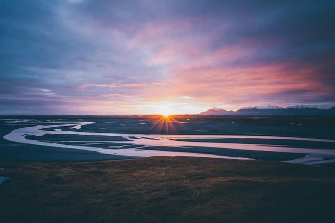
Those lucky enough to find themselves journeying along this famous sightseeing route on the coast will see the South’s otherworldly landscapes change drastically from beginning to end.
What starts with quaint country meadows soon becomes towering plateaus that slide gracefully into jet-black deserts.
Moving deeper into the south-east of Iceland, the lush glacial beauty of Skaftafell rises up from the barrenness like an oasis.
In many ways, the exquisite beauty of this region seems to defy reality itself, and as such, attempting to convey such a thing in words feels like a futile effort.
South Iceland is a place that, quite frankly, must be seen to be believed.
So first, let’s take a look at some standard information about South Iceland, before moving on to its many black sand beaches, glaciers, volcanoes, lagoons and hot springs.
Basic Facts About South Iceland
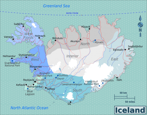
South Iceland covers 24,256 km² and is home to approximately 28,399 people, with 6,000 living in its largest town, Selfoss.
The region is sometimes referred to as the ‘South Coast’ by tourist vendors and other information providers.
The area can be visited during both the summer and winter, with the exception of the Icelandic Highlands, which is generally only accessible from May till September due to weather constraints.
The Highlands are not technically a part of South Iceland but there are a number of routes that access the Highlands directly from the South, so-called F-roads.
Sightseeing tours of the south coast are available throughout the year. Day tours in the summer can reach as far East as Jökulsárlón glacier lagoon while winter tours offer the chance to go Northern Lights hunting.
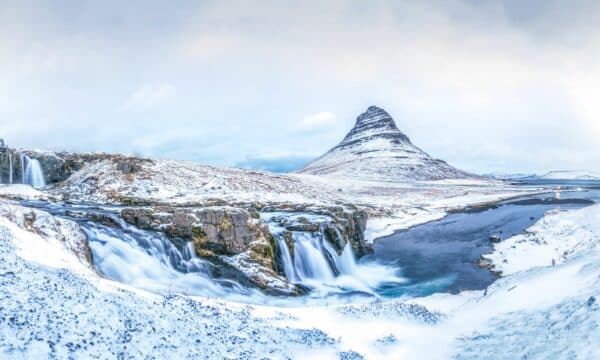
Waterfalls in South Iceland
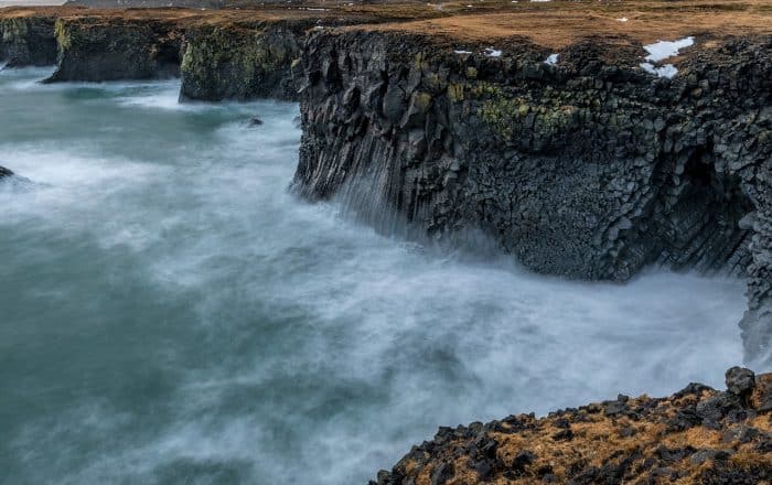
Ancient sea cliffs enclose the landscape of South Iceland.
When travelling in this area, you’ll notice the roaring waves of the Atlantic Ocean to your South, and massive cliffs of what was once, Iceland’s coastline, in the North.
These former coastlines—blessed with a Narnian aesthetic—were formed over hundreds of thousands of years.
They are the results of the culmination of receding sea levels, volcanism and the movement of the Reykjanes Ridge, a meeting point of two tectonic plates on which much of the south-west lies.
Quite simply, the cliff sides seen today demonstrate Iceland’s active landscape.
Falling dramatically from these coastal cliff sides are some of the South’s most beloved waterfalls.
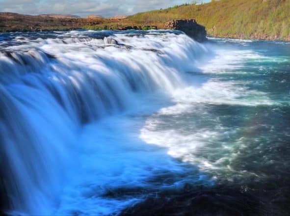
Seljalandsfoss and Skógafoss are both staple points-of-interest for sightseers in the area and are accessible by the Ring Road. Almost all guided sightseeing tours of South Iceland make a stop at these stunning cascades.
Although these two features are considered the star attractions of the South Coast, there are countless other waterfalls found here worth your visit. I’ve listed a few should you be planning a self-drive tour and are looking for a unique detour.
Seljalandsfoss
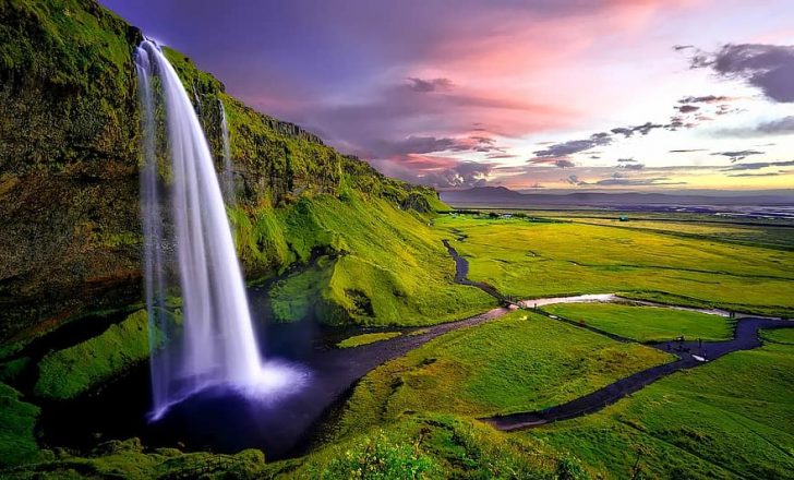
Dropping a total of 60 metres, the white glacial water of Seljalandsfoss topples majestically over a pleasant green cliff.
- Don’t miss out on these brilliant Off the Beaten Path tours in Iceland
The feature’s greatest highlight is the footpath that provides access directly behind the cascading water; a novelty, even here in Iceland.
Walking behind Seljalandsfoss for this rarely-seen perspective has become something of a tradition amongst visitors, and is of particular interest to landscape photographers looking for their own take on that oh-so-famous shot.
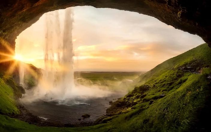
It can be difficult to venture behind the waterfall in the winter, and sometimes the route is closed when there is too much frost.
However, winter brings darkness, and then flood lights illuminate the waterfall in full, creating a truly dazzling nighttime scene which every photographer should try to capture.
Gljúfrabúi
Another footpath leads on from Seljalandsfoss to a narrow crag in the cliffside, barely noticeable save for the trickling stream running gently from it.
Adventurous visitors might want to follow that stream, for hidden inside the cliff is the gorgeous waterfall Gljúfrabúi, or “Gorge Dweller.”
In truth, this mystical feature is only partially hidden by the cliffside.
At 40-metres high, with multiple rivulets forming into a layer-cake cascade, Gljúfrabúi makes for a fantastic visual in its own right.
If you have enough time, visiting this cascade is more than worth the extra effort.
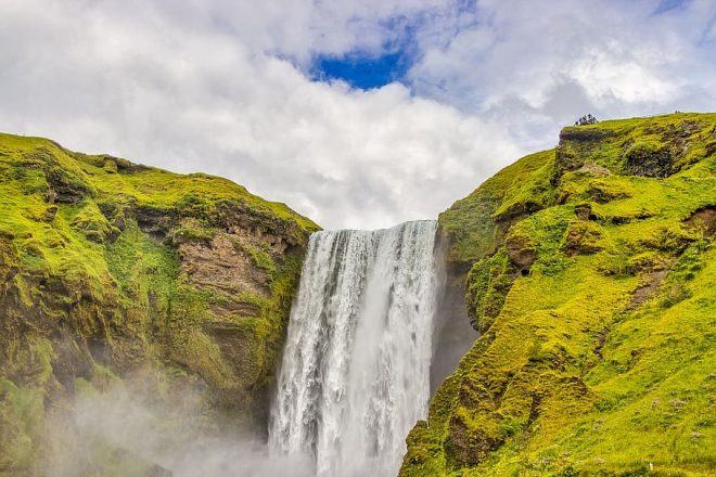
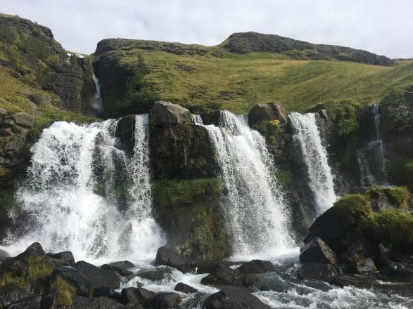
Skógafoss
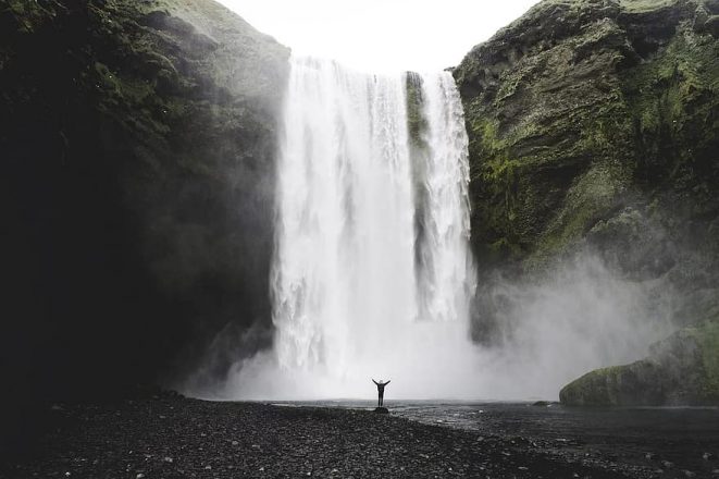
Skógafoss waterfall boasts a height of 60 metres and a total width of 32 metres, making it a far-more dramatic sight than its neighbour, Seljalandsfoss.
The land underneath the waterfall is very flat, making it possible to walk right up to the cascading water. However, doing so will make you wet so make sure you bring a raincoat.
- Looking for ideas for your holiday? Read our feature article The 14 Best Things To See and Do in Iceland
Photographers and nature-lovers alike will delight in the rainbows that form in this waterfall’s mist—that is, when the sun becomes clear of a cloud cover.
There is a staircase next to Skógafoss, which leads to an observation platform, providing visitors with a fantastic view of the waterfall and the surrounding countryside.
Gluggafoss / Merkjárfoss
Located halfway between Hvolsvöllur town and Þórsmörk, the site known as both Gluggafoss (Window waterfall) or Merkjárfoss, actually refers to a series of picturesque waterfalls on the Merkjá river.
The first waterfall pours in a narrow line down into a shimmering spring below, before breaking off into three shorter rivulets.
- Thinking of visiting in the winter? Make sure to see our Winter Holiday Packages
But not many know that the waterfall’s current appearance is only a recent development.
At 53 meters high (174 feet), it is hard to believe that before the late year of 1947, rocks had shielded the waterfall entirely from view.
The cliffs are made from soft volcanic rocks and in the last fifty years or so, the turbulent water eroded through the foundation, creating holes or “windows” for which the waterfall is named.
Given that the south of Iceland is still considered extremely volcanically active today, it is expected that this waterfall will likely change quite dramatically in the years to come.
There are a number of other impressive waterfalls in the nearby area, including Þórðarfoss, Drífandifoss and Bleiksárfoss.
Faxi
Faxi is a waterfall on the popular salmon-fishing river, Tungufljót. It is sometimes included as an extra stop for visitors on the Golden Circle sightseeing tour.
- Choose your dream holiday in Iceland with our Small Group Guided tours.
While certainly not as large or dramatic as nearby Gullfoss, Faxi waterfall certainly has its charms. A gushing 7-metre drop stretches an impressive 80 metres, creating a gentle break in the river, and there is a natural staircase which the salmon swim up every season.
Faxi translates to horse mane, as this is what the first settlers believed its raging waters resembled.
Svartifoss Waterfall
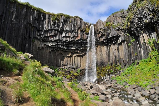
With a name that translates directly to black waterfall, visitors are right to expect Svartifoss to be a rather impressive site.
Thankfully, those who make an effort to visit this cascade in Skaftafell Nature Reserve rarely leave disappointed.
- See this stunning region yourself with this 3-Hour Glacier Hike in Skaftafell Nature Reserve
Falling twenty-metres over the lip of an ancient half-moon shaped cliff, Svartifoss is arguably most well-known for its incredible geology.
Similar to those at Reynisfjara beach, the rocks here have formed into strange hexagonal shapes that make this site entirely unique when comparing other waterfalls in the country.
These black basalt columns were the main inspiration behind the post-modern architecture of Hallgrímskirkja Lutheran Church, Reykjavík’s most recognisable landmark.
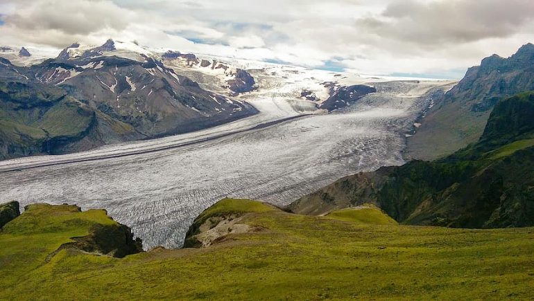
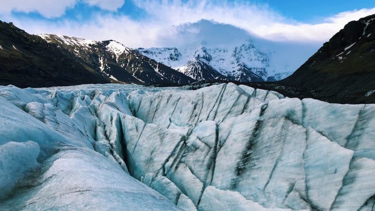
Vatnajökull National Park
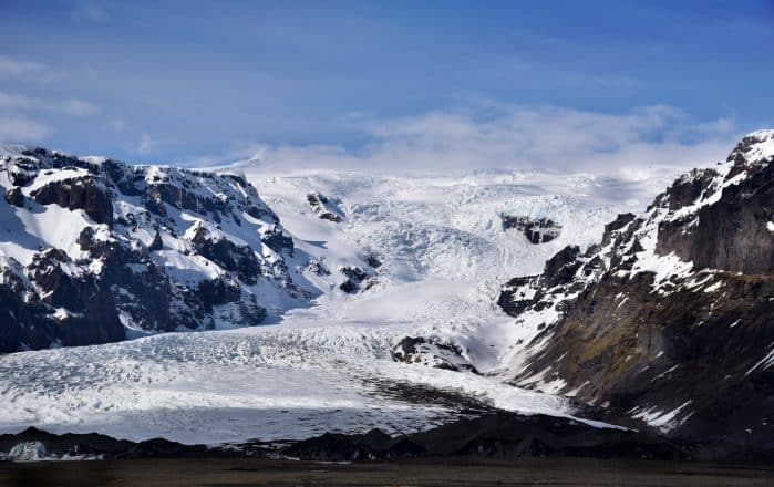
Ah, the mighty Vatnajökull glacier—the biggest of all the ice caps in Iceland (and Europe), with a total area of 7900 kilometres2 (3100 square miles).
Covering 8% of the country, Vatnajökull swallows mountains, valleys and volcanoes beneath its enormous ice sheet, which averages a staggering 380 metres (1,250 ft) thick.
This includes hiding Iceland’s highest peak, Hvannadalshnúkur, a fact that, hopefully, provides some perspective on just how enormous Vatnajökull really is.
Given this grand glacial beauty, it should really come as no surprise that the ice cap, and the surrounding area, has constituted a national park since 2008.
Skaftafell Nature Reserve
Skaftafell was once a national park in its own right. It was merged into Vatnajökull National Park on June 7th 2008, and now is considered a nature reserve.
Skaftafell is best suited to hikers, climbers and adventure seekers drawn to what is some of Iceland’s most staggering natural scenery.
Aside from its glacial mountainsides and lush green trails, there are countless points of interest found in the Skaftafell region.
Take the epic bird cliffs of Ingólfshöfði Cape, the monolithic Lómagnúpur mountain, or even the scenic viewpoint, Sjónarnípa, which overlooks Jökulsárlón and Fjallsárlón glacier lagoons.
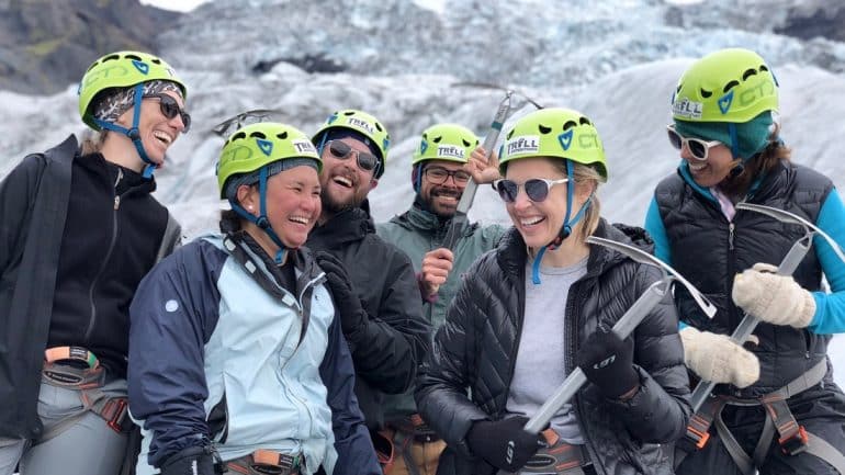
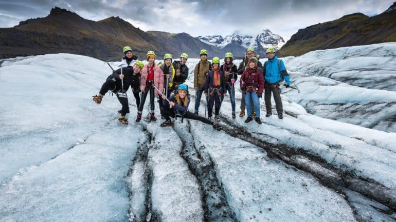
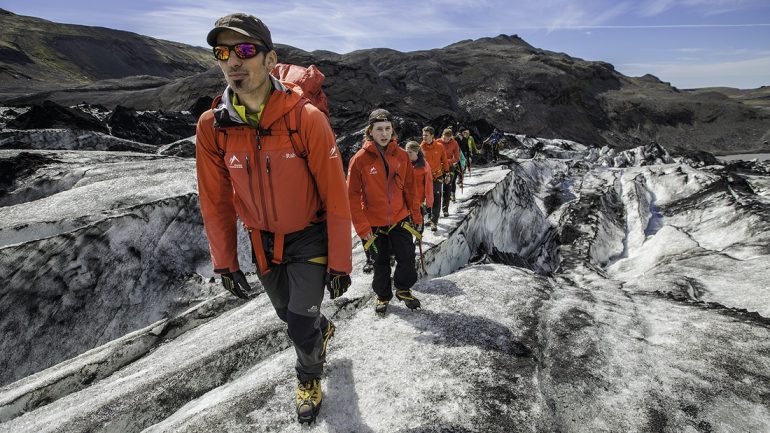
The outlet-glaciers Svínafellsjökull (pig mountain glacier) and Falljökull (falling glacier) are also considered two highlights for those hiking through this picturesque region. Those looking for a better view of these ice giants can take one of many glacier hiking tours available in Skaftafell.
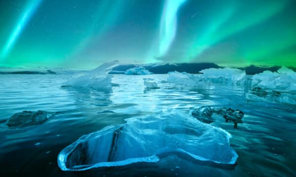
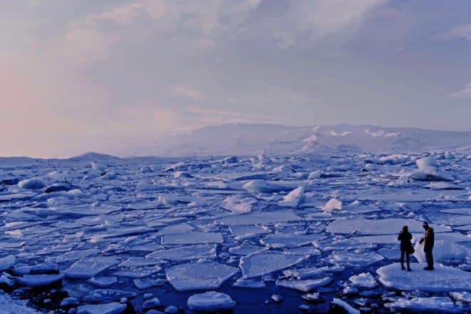
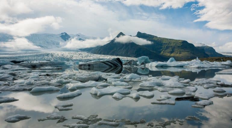
Jökulsárlón and other Glacier Lagoons
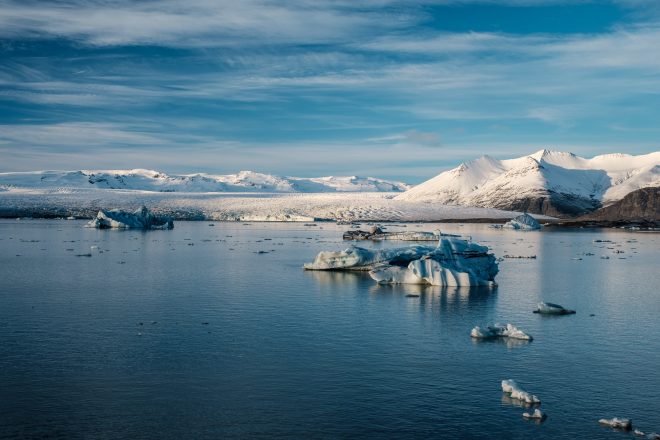
Jökulsárlón is a world-famous, iceberg filled glacier lagoon in Vatnajökull National Park in South-East Iceland, about 377 km (234 mi) from Reykjavík.
Its ethereal beauty and dramatic surroundings are, no doubt, one of the major reasons behind the park’s designated UNESCO World Heritage site status.
Visitors to this site—often nicknamed ‘the Crown Jewel of Iceland’—will watch from the lagoon’s pebbled banks as enormous icebergs break from Breiðamerkurjökull glacier and begin floating out to the Atlantic.
All the while, the magnificent scenery of Vatnajökull National Park surrounds you, a testament to the might and majesty of Mother Nature.
Jökulsárlón also happens to be the deepest lake in Iceland and is a delightful place to see resident seals poke their heads out above the water.
Diamond Beach
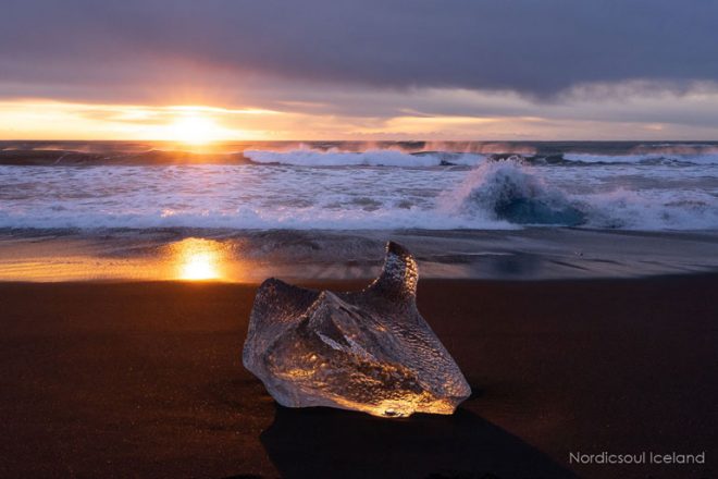
Diamond Beach can be found across the road from Jökulsárlón.
- Maximise your trip in Iceland with this 8-Day Summer Self Drive Tour Around the Ring Road | Golden Circle, Glacier Lagoon, Remote East Iceland & Akureyri
Given that it takes only few minutes to hop between the glacier lagoon and the beach, most visitors will make sure to visit both locations while in the area.
During the summer months, photographers will be able to capture icebergs washed up against the beach’s black sand, creating a stunning contrast made all the better thanks to the optimal lighting of the Midnight Sun.
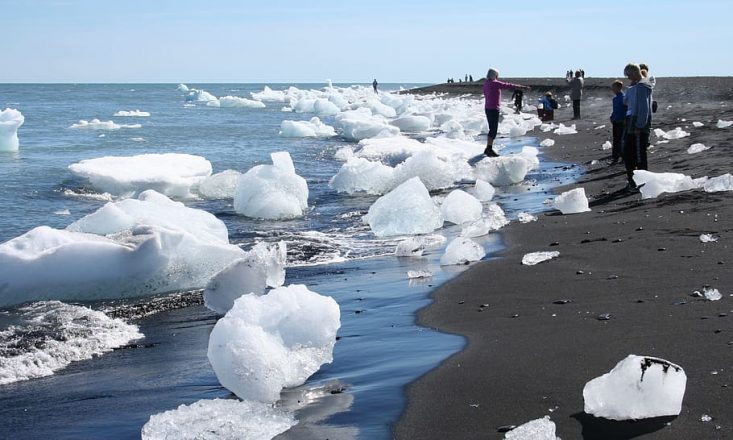
In the winter, however, the glittering blue icebergs that make their way out from Jökulsárlón to sea are of a much larger size—so much so, in fact, that you might feel more like you’re visiting Greenland or the Antarctic rather than little-old Iceland.
Fjallsárlón
Fjallsárlón is a glacier lagoon found near its more famous neighbour, Jökulsárlón.
The site offers impressive views over Lake Breiðárlón, especially of the dense, aquamarine wall that is Breiðamerkurjökull glacier rising up from the water.
Above this stunning panorama, the mighty Öræfajökull volcano looms over all.
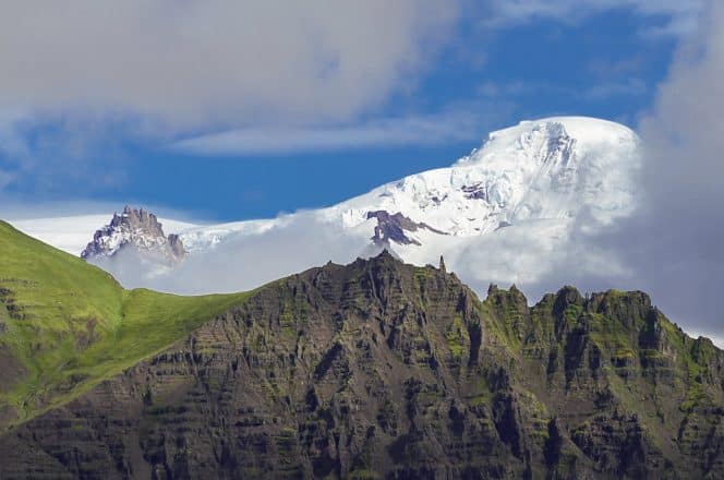
Öræfajökull stands at a formidable 2110 metres. It’s easy to feel both awed and intimidated by this giant force of nature, and it’s not entirely with reason. Öræfajökull remains the largest active volcano in Iceland—though don’t worry too much; it’s only erupted twice in recorded history, and that was in 1362 and 1727.
The glacier lagoon is such an icon location that it has been used by Hollywood productions such as James Bond: Die Another Day and Lara Croft: Tomb Raiser. The popular Icelandic blues band, Kaleo, also used the lagoon’s icebergs as a makeshift stage in their music video, ‘Save Yourself.’
Though Fjallsárlón and Jökulsárlón are both beautiful sites worthy of anyone’s time in South Iceland, they do come with a caveat.
Like squawking guardian angels, the lagoon’s shores are used as nesting grounds in the summer by Arctic skuas and Arctic terns, two species known for aggressively defending their chicks.
People who’ve ventured too close to a nest are often seen running through the car park, backpacks held over their heads as the birds dive-bomb mercilessly around them.
Black Sand Beaches in South Iceland
Geologically speaking, Iceland is a very young country, and even today, its landscape continues to be sculpted and reshaped by the elements.
One way this topographical vitality can clearly be seen is in the many black sand beaches that decoratively line Iceland’s south coasts.
These visually-stunning phenomena are made up of sand that is actually residues of basalt lava, somewhat common in South Iceland given its many volcanoes.
So where can South Iceland’s most famous black sand beaches be found?
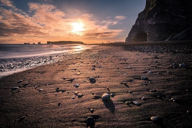
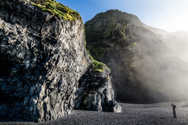
Reynisfjara Black Sand Beach
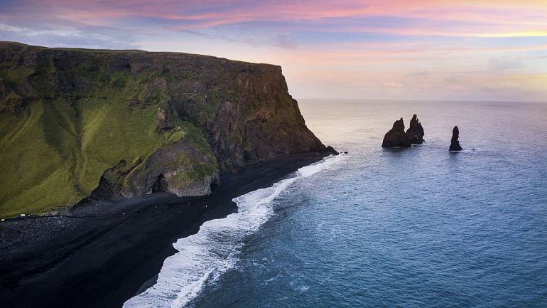
188 km (117 mi) from Reykjavík you’ll find Iceland’s most famous black sand beach, Reynisfjara. The beach is located right beside the village Vík í Mýrdal and has long served as the small town’s biggest allure.
- Visit Reynisfjara during the winter with our Winter Tours.
The North Atlantic splashes and crashes against the dark volcanic pebbles of Reynisfjara, often reaching extreme distances up the beach.
Signs along the shore warn of this danger, but still to this day, visitors underestimate just how powerful the ocean can be here.
Standing at Reynisfjara feels akin to being centre stage at a colosseum. The beach is enclosed by hexagonal basalt rocks, often mistakenly known as Garðar (—this is actually the southernmost farm in Iceland).
These dramatic rocks formations—reminiscent of auditorium stone seats—extend to Hálsanefshellir cave which sits like a strange and empty pirate cove on the corner of the beach.
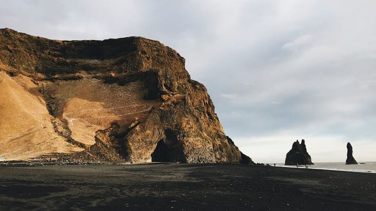
The rock stack Reynisdrangar is a landmark in its own right. At 66 metres tall, these dark pillars stand forever out of the ocean, still and silent, hinting at the beach’s threat like the petrified remains of an ancient troll.
Thanks to its phantom beauty, Reynisfjara has proven to be a popular filming location for Hollywood productions.
Huge entertainment franchises, including Star Wars and Game of Thrones, have capitalised on the beach’s spooky aesthetic to help construct their immersive fantasy worlds in celluloid.
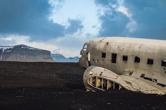
Sólheimasandur Black Sand Beach & DC Plane Wreck
The dramatic black sands of Sólheimasandur are the result of a powerful glacial wash, or Jökulhlaup, that occurred between the years 1245 and 1262 following the eruption of Katla volcano.
Jökulhlaups are triggered by geothermal heat or volcanic eruptions under glaciers which melt a large portion of the ice cap creating an outburst flood.
It is thought that the jökulhlaup which created Sólheimasandur was so forceful that its flow rate is estimated at 300,000 – 400,000 metres squared per second.
The Sólheimasandur area is divided up by the winding glacial river, known as the Jökulsá á Sólheimasandi, which originates from Sólheimajökull glacier.
DC Plane Wreck
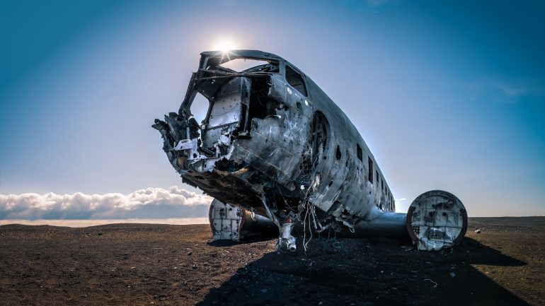
Not all of Iceland’s famous attractions are natural. Laid out like a skeleton on the black sands of Sólheimasandur, the DC plane wreck is the perfect destination for those travellers looking to truly see it all.
The plane wreckage has become something of a cultural ambassador for Iceland given its wide scale use as a subject in tourism campaigns, music videos, products.
Standing amid the rocky desolation of Sólheimasandur, it’s hard to imagine how anyone could survive crashing an aircraft here. However, the story is anything but tragic.
The flight seemed to doom from the outset. When the engines failed, the fog was thick around them; treacherous conditions that an inexperienced crew were hardly confident in dealing with.
The flight captain, James Wicke, made the decision to glide the plane towards the ocean, in the hope of a sea landing. When they descended below the fog, however, he saw they had miscalculated and were still above land—what he later described as ‘some place on the surface of the moon.’
Miraculously, all crew members survived the emergency landing, but there was so much significant damage to the aircraft that it was left abandoned to the elements.
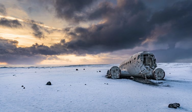
In the years since, the wreckage was used as a makeshift storage shed by the land’s owner, and hunters would routinely use it for target practise, hence its many bullet holes.
The aircraft, a United States Navy Douglas Dakota, crashed on 21 November 1973. You will find that this given date—taken here from an MBL interview with those crew members involved—is often found to be inaccurate on other websites.
The plane is also often referred to as a Super DC-3, so much so that this is now the famous name the site goes by. However, this is not quite correct either, as the aircraft was actually officially classified as a Douglas C-117.
You can reach the plane wreck by walking from the car park south of Ring Road, located between Vík and Skógar waterfall. However, this journey should only be taken in good weather or with a guide as the route is long and you are completely exposed to the elements.
Stokksnes Peninsula & Vestrahorn Mountain
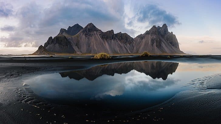
The black sand dunes of Stokksnes peninsula are located nearby to Höfn town. They serve as the backdrop for what is, arguably, the most famous mountain in South East Iceland; Vestrahorn.
- Take part in this unforgettable 10-Day Winter Small Group Guided Tour of Iceland
Vestrahorn is easily recognised thanks to its sharp mountain peaks, which rise dramatically from the dark sands to a towering 454 metres (1490 ft).
Glacier & Volcanoes of South Iceland
Covering 11% of the island’s total landmass, Iceland’s mighty glaciers are so large that they cowl the mountains and volcanoes beneath them.
This can be confusing for travellers expecting your traditional, cone-shaped volcanoes and sharp-ridged peaks. As such, we have classified volcanoes and glaciers together in this section, as they often go hand in hand.
Volcanoes that are covered by ice caps are better classified as subglacial volcanoes. Those found in Iceland are generally low-lying, but one shouldn’t underestimate them.
In their magma chambers, the earth continues to churn and boil, waiting, it seems, for that perfect breaking point
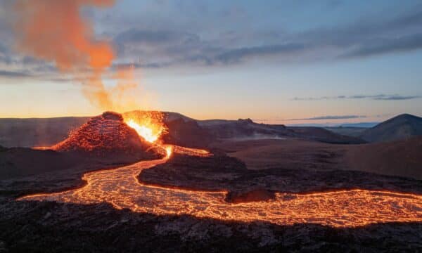
This might sound frightening, but South Iceland has always been an incredibly volcanic area, with eruptions common here throughout the island’s history.
Katla Volcano & Mýrdalsjökull Glacier

Over twenty eruptions were documented at Katla between the years 930 and 1918. With a rough interval of 20-90 years between, this makes the volcano one of the most active in Iceland.
This is somewhat daunting, given Katla’s sheer size, and the fact that an eruption has not been seen there in over a century. This would mean, a touch worryingly, that an eruption is overdue at Katla.
Scientists are actively monitoring for increased volcanic activity in the area. Seismic tremors have been observed in recent years, notably 2011, 2016 and 2017.
Though this initially caused some concern among Icelanders, volcanologists quickly soothed their worries, explaining that small earthquakes are common throughout South Iceland.
In case of an eruption in one of South Iceland’s volcanoes, an emergency evacuation plan exists. All mobile phones in the area will receive a text message with directions on how to proceed.
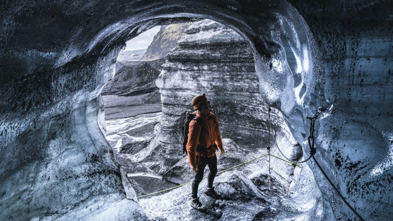
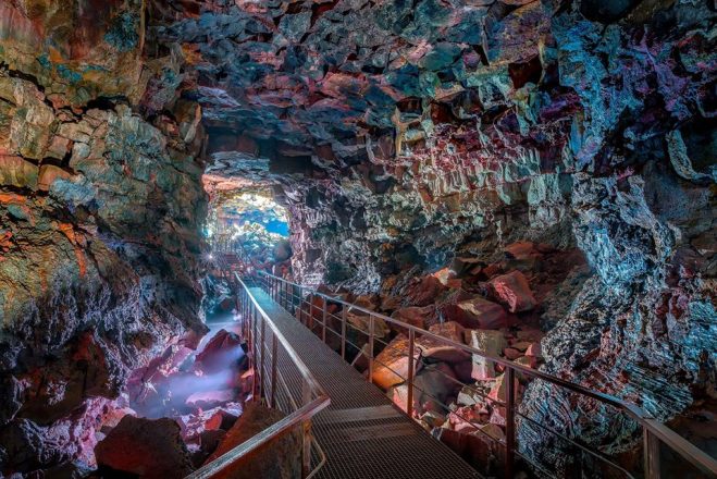
Ice caving tours at Katla are particularly popular amongst guests. Unlike the ice caves found at Vatnajökull, these are available to visit throughout the year, providing guests the chance to explore the inside of Iceland’s glaciers, even when the weather is beautiful outside.
Eyjafjallajökull
A reasonably small ice cap by Icelandic standards, Eyjafjallajökull glacier can be seen from the window while driving on the Ring Road, and makes for a popular stop among hikers.
Looking at its immense ice sheet, one would not guess at that lying beneath is a volcano of cataclysmic power—one that has already proven its explosive potential in the early part of this century.
Many credit Eyjafjallajökull’s eruption to Iceland’s tourism boom in the years following its 2010 eruption. This is because the world’s media shone a spotlight on the country thanks to both the drama of the footage, and the enormous ash cloud so large that it halted European air traffic.
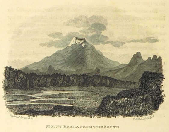
Hekla
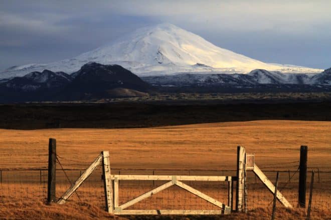
Hekla is another of Iceland’s highly active volcanoes, standing at 1,488 m (4,882 ft). Like Katla, over twenty eruptions have been recorded there since the early settlement period.
In medieval times, the Europeans described Hekla as ‘The Gateway to Hell’, a nickname that followed a particularly explosive eruption in 1104.
We know this because tales of the volcano’s fury travelled by word of mouth throughout the continent. These were later ratified by the monk, Herbert of Clairvaux, who summed Hekla up nicely in his work, Liber De Miraculis;
‘The renowned fiery cauldron of Sicily, which men call Hell’s chimney … that cauldron is affirmed to be like a small furnace compared to this enormous inferno.’
— Liber De Miraculis, 1180
The volcano’s infamous reputation has permeated into popular culture over the years.
Today, one will find its name and likeness being used around the world by businesses and products, as well in literature, cinema and music. Even the Danish football team, DBU Copenhagen, play in a stadium called Hekla Park.
Towns in South Iceland
There are a number of pleasant towns found in South Iceland, each of them excellent stops for an overnight stay or a bite to eat.
Below, we have gathered information on the larger towns that you’ll likely travel through on your travels.
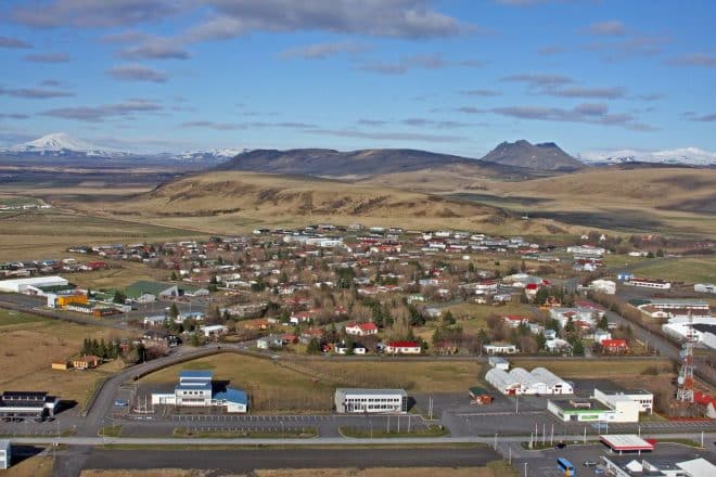
Selfoss
According to the Icelandic Sagas, the Selfoss area was known to this country’s earliest Viking settler, Ingólfur Arnarson, as early as 873 CE when he spent the winter ‘west of Ölfusá River.’
Only 58 kilometres (36 mi) from Reykjavík, Selfoss has been a centre of trade and commerce since the construction of Iceland’s first suspension bridge in 1891—a major breakthrough in infrastructure back in the day!
Providing passage between two regions over the Ölfusá river, Selfoss saw an enormous population growth from the mere 40 people who lived there in 1900; so much so, that today, Selfoss serves as the region’s largest town and home to approximately 6000 of its people.
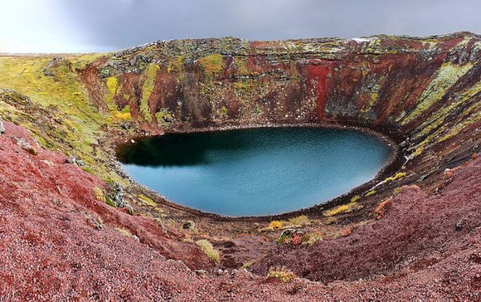
Selfoss is within easy access to the Golden Circle sightseeing route, as well other interesting stops like Kerið volcanic crater.
Hveragerði
Slightly closer to Reykjavík than Selfoss, you’ll find the pleasant town of Hveragerði. It is famous for its greenhouses, and throughout the year, these buildings are filled with succulent tomatoes, bell peppers, cucumbers and flowers.
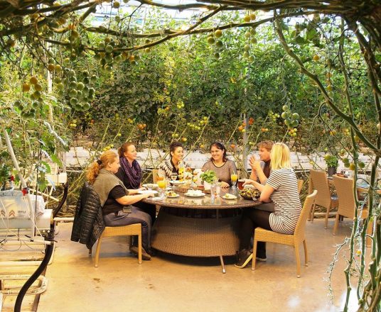
The greenhouses can be visited at Friðheimar tomato and horse farm, one of the town’s biggest allures for visitors interested in tasting fresh produce and learning more about unique and authentically Icelandic agricultural practises.
This incredible focus on organic growing methods is made possible thanks to the geothermal heat that bubbles beneath the town’s surface (—and over it, with billows of steam a common sight along Hveragerði’s streets.)
Hverasvæðið geothermal park is found in the centre of town, and other attractions nearby include Raufarhólshellir lava tunnel and the geothermal bathing area Reykjadalur Valley.
Culture lovers should also check the Listasafn Árnesinga art gallery, as well try some classic Icelandic yoghurt at the cafe-restaurant, Skyrgerðin.
Vík í Mýrdal Village
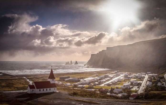
Vík í Mýrdal—often shortened simply to Vík—is Iceland’s southernmost settlement. The town is 180 kilometres (110 miles) from Iceland’s capital city, Reykjavík, and is advantageously located on the Ring Road.
Vík is home to around 300 permanent residents, most of whom work in the tourism sector as in recent years, the town has become a popular stop for those travelling the south coast.
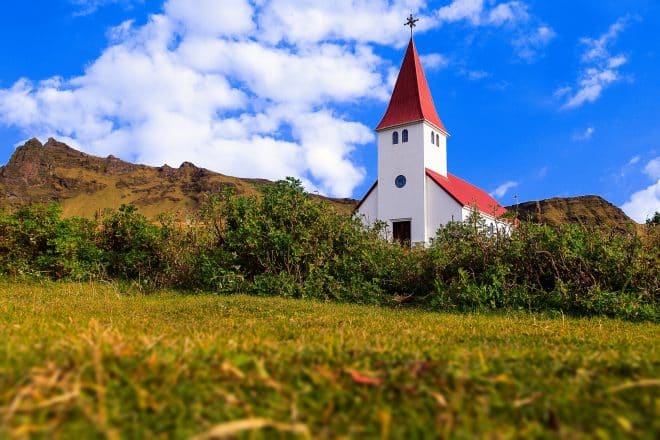
Statistically, Vík’s geographical position makes it the warmest village in the country. The weather can make it a pleasant lunch stop during the summer, especially for those who just visited the nearby Reynisfjara black sand beach. However, Vík is also the wettest coastal town, so make sure to bring an umbrella.
Höfn
Höfn (sometimes referred to as Höfn í Hornafirði) is a burgeoning town in the south east of Iceland, with a population of approximately 2200 people. Aside from tourism, the town’s biggest industry is fishing, much of which revolves around the rare Norway lobster.
The town has become an economic centre for the whole Vatnajökull area, boasting a campsite, hotels, sport amenities, restaurants and swimming pool.
Those looking to spend a few days photographing Jökulsárlón glacier lagoon in different lighting conditions will want to make Höfn their homebase.
Guests to the town could also choose to do any number of cultural activities. This includes a visit to the oldest shop in Höfn, known as Gamlabúð (“Old Shop”), or take a leisurely stroll around its pleasing harbour. Travellers will also find Vatnajökull National Park visitors’ centre in town.
If you are visiting at the end of June, make sure to check out the annual Lobster Festival where you’ll have plenty of opportunities to try Höfn’s famous cuisine.
Flúðir
The green and pleasant town of Flúðir has an approximate population of 400 people. Given the high tourist traffic moving through each year, this often gives the impression of it being a lot busier than it really is.
The town is best known for its close proximity to the attractions of the Golden Circle, and for being home to Iceland’s oldest outdoor pool, the Secret Lagoon.
Surprisingly enough, Flúðir has one of the best Ethiopian restaurants in the country.
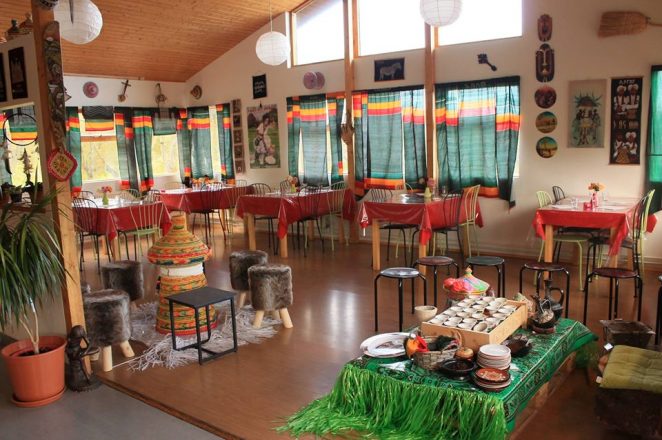
While this small and laidback eatery may not seem particularly authentic given its surroundings, its dishes like doro kitfo (chicken) and awaze tibs (spicy lamb) make it a must-stop for travelling foodies.
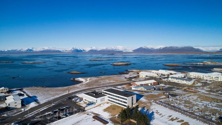
Hvolsvöllur
Hvolsvöllur is something of a novelty given that it’s the only town in Iceland not to be settled besides the sea or a river, but was instead founded to act as a service centre for surrounding agriculture.
Today, its location makes it an excellent base of operations for those looking to explore South Iceland over a few days.
Visitors to Hvolsvöllur have a number of exciting options when it comes to nearby attractions and activities.
For one, an airfield nearby offers trips to Vestmannaeyjar, otherwise known as the Westman Islands, a scenic archipelago off the southern coastline.
More options might include discovering the hidden waterfall, Nauthúsagil, a number of sites from the Katla Geopark, or taking a stroll around the fascinating history museum, Saga Center.
Not only does this town of around 1000 people have ample accommodation and amenities, but it’s advantageously positioned so as to head out east on the Ring Road, and see the rest of the region.
The Lava Centre in Hvolsvöllur
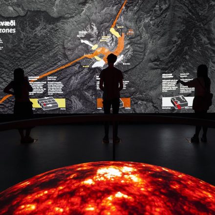
One of the Hvolsvöllur’s best indoor attractions is the Lava Centre, a fun and interactive exhibit dedicated to the powerful geological forces that, to this day, continue to shape Iceland’s landscapes.
Through a series of high-tech displays, curated artifacts and dramatic film clips, guests to the Lava Centre will learn all there is to know about volcanoes, magma, tectonic plates, and even Iceland’s violent former eruptions.
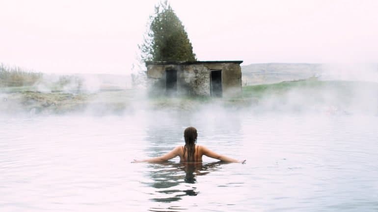
Hot Springs & Spas in South Iceland
Bathing in natural hot springs is an Icelandic tradition that can trace its roots back to the initial settlement. In a land so often devoid of heat, these bubbling pools of pure water must have seemed like a miracle to weary travellers.
- Browse our selection of Hot Springs and Swimming Pools products
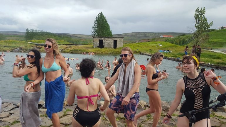
Today, Iceland’s hot springs and spas and best enjoyed in good company. Thankfully, there are many places in South Iceland that visitors can go to soak their bodies and feel waves of relaxation wash over.
Reykjadalur Valley
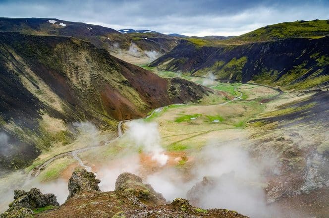
With a name translating to ‘Smokey Valley’—this is interchangeable with ‘Steamy’ in Icelandic—visitors would be right to expect geothermal activity in this lovely area only forty-five minutes from Reykjavík.
Slicing through its luscious sloping hillsides, the site is most famous for its hot river. Shallow enough to sit in comfortably, with temperatures flowing from hot to cool, this gorgeous and entirely natural bathing spot attracts hundreds of guests a year.
Reaching the river does require a bit of trek, but this should be no issue at all for healthy travellers. At 7 kilometres there and back, it would be wise to give yourself three hours or more to fully maximise your experience.
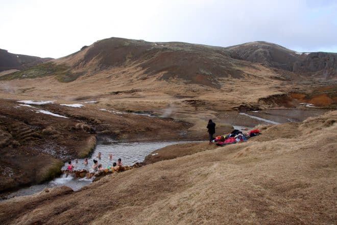
This is hardly a put-out. Reykjadalur Valley is widely considered one of, if not the most beautiful hiking area in the whole Ölfus region.
This site can be found nearby to Hveragerði town, only adding to the litany of reasons to pass through.
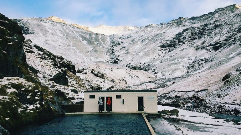
Seljavallalaug
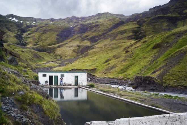
Seljavallalaug, sometimes known as Seljvavellir, is a white outdoor pool embedded beneath a row of lush volcanic hillsides, not far from Skógafoss waterfall.
First built for training young swimmers in 1923, Seljvavellir is one of the country’s oldest pools, and is now an officially protected site.
The pool measures 25-metres in length, 10-metres across, and is entirely free to enter. Note that there are no lifeguards on duty, and the green-algae that covers the bottom and sides of the pool can be quite slippery.
Laugarvatn
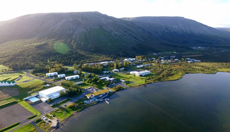
A shallow but picturesque waterbody, Laugarvatn is a geothermal lake found nearby to Þingvellir national park, Geysir valley and Gullfoss waterfall. Residing on its western banks, the town of the same name is home to around 200 people.
The area is most widely visited due to the Fontana Laugarvatn spa, a special addition to the town that utilises the lake’s underwater hot springs. This has historic precedent, as local residents have been bathing in Lake Laugarvatn’s waters since 1929.
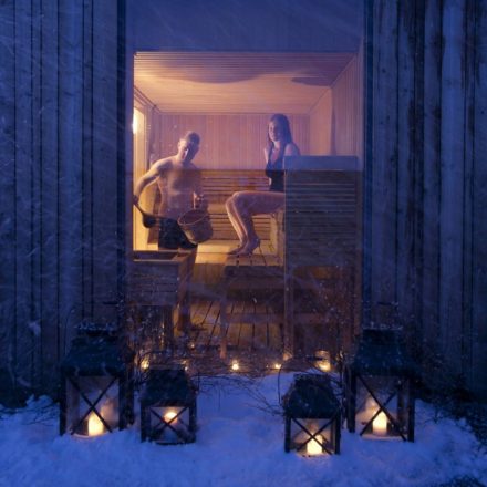
What’s changed is the luxuries and modern amenities offered alongside this relaxing heat. Fontana Laugarvatn offers baths and steam rooms, a variety of decorative outside pools and Finnish-style saunas.
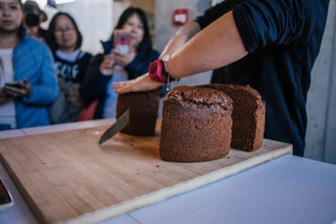
Fontana is also one of the best places in South Iceland to see Rye bread being made by the old traditional methods; baking using geothermal heat. Make sure to try some on your way between the pools and the cafe.
There are even quaint wooden piers from which spa guests are invited to jump into the lake itself. Be warned, as this is purely for those looking to experience the rejuvenating health benefits of cold-water bathing, said to improve muscle recovery, heal soreness and increase blood circulation.
Secret Lagoon
The Secret Lagoon in Flúðir is Iceland’s oldest outdoor swimming pool, tracing its origins all the way back to 1891.
Now a popular and modern resort widely stopped at during Golden Circle sightseeing trips, the water remains at a perfect 38-40 degree’s Celsius throughout the year, making it a fantastic bathing spot while watching the Northern Lights in the winter.
In between bathing, make sure to check out the steaming fumaroles and bubbling mud pots that surround the lagoon, as well as provide its soothing heat.
The small, but fascinating geothermal area that serves as the foundation of the Secret Lagoon is known as Hverahólmi. It has been the lifeblood of Flúðir town for generations.
Everything about visiting the Secret Lagoon is a calm and tranquil experience. There are indoor showers, changing facilities and lockers on-site, as well as a bar and small cafe, which only adds to the ease of one’s stay here.
Other Points of Interest in South Iceland
South Iceland’s countryside is so peculiar in its form, origins and aesthetic that some natural attractions are difficult to categorise.
As such, we have included other prominent points of interest, be they panoramic view points, sweeping canyons or black sand deserts.
Dyrhólaey
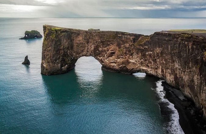
There are countless reasons to stop at Dyrhólaey promenade, a former island that now boasts a reputation as one of the best viewing areas on the South Coast.
Only 174 kilometres from Reykjavík—not to mention being accessible from the Ring Road—guests from the capital can make it here and back again in a single day, with time left over for stopping at waterfalls.
- Learn more about this iconic Icelandic resident in Everything You Need to Know About Puffins in Iceland
Dyrhólaey is perhaps best known for the impressive 120-metre high rock arch that stands proudly over the crashing waves of the Atlantic Ocean. The promenade takes its name from this impressive feature, translating to “The Hill Island with the Door Hole”.
The second reason to visit Dyrhólaey is for its lighthouse. Aside from the castle-shaped building being a photogenic subject in itself, standing beside it provides incredible views of both Mýrdalsjökull glacier and the South’s coastline, extending all the way to the famous rock stack, Reynisdrangar
- See South Iceland in style with any one of these Privately Guided Tours
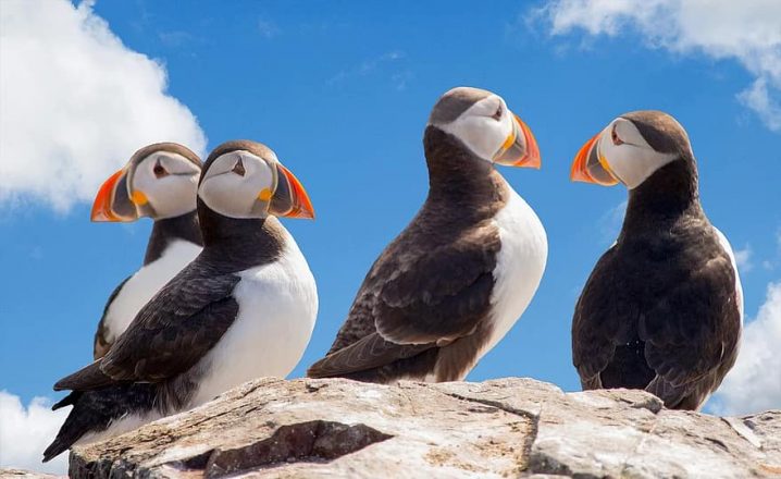
Finally, if you’re planning on visiting during the summer months, make sure to keep an eye out for nesting Puffins soaring around the cliff sides. Other birds that call Dyrhólaey home include Arctic Terns and Northern Fulmar.
Fjaðrárgljúfur canyon
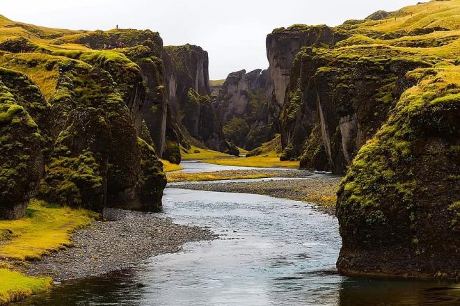
Notoriously unpronounceable—so much so, it could give Eyjafjallajökull a run for its money—Fjaðrárgljúfur is a stunning canyon found in South Iceland as part of the Katla Geopark.
Dramatic and eye-catching, even for South Iceland, Fjaðrárgljúfur is thought to have formed at the end of the last Ice Age, roughly 9000 years ago.
Visitors to the site will see a light river, Fjaðrá, trickle between sheer, vertical walls of moss-laden cliffs, creating an otherworldly allure that can be perfectly captured by experienced landscape photographers.
At some points, the canyon bed lays as deep as 100 metres, but the water is shallow enough to make walking here easy, albeit with some wading involved.
In total, the canyon extends for 2 kilometres, a perfectly hikable distance that makes it an excellent detour in between the more famous attractions on the South Coast.
Öræfi – “The Wasteland”
Otherwise known as Öræfasveit, Öræfi is a wash of black sands found east of Öræfajökull volcano. It falls within the boundary lines of Vatnajökull National Park.
Due to the rivers that cut through the east and west of the wilderness, Öræfi was considered a very isolated area until the Skeiðará bridge was built on the Ring Road in 1974.

Before 1362, the area was known as Hérað or Litlahérað (‘Shire’ or ‘Little-Shire’) and no doubt looked much more pleasant and full of life then.
Now empty and barren, the area’s name changed after a mighty eruption at Öræfajökull in 1362. The explosion caused heavy glacial flooding that washed across the low-lying plains at the mountain’s base.
This might not have been much cause for concern, save the local farmstead in its path. After the tragedy, the area was abandoned for safer pastures, and ever since has been referred to as Öræfi or ‘The Wasteland’.
Vestmannaeyjar (Westman Islands)
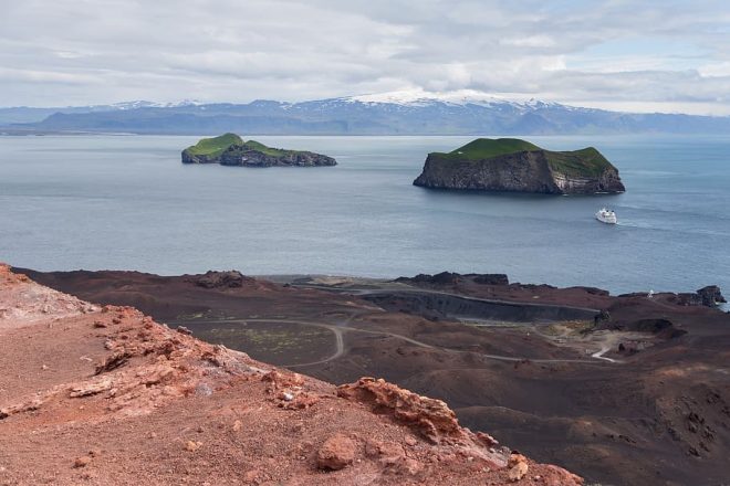
A southern archipelago of exquisite charm and beauty, the Westman Islands are, perhaps, South Iceland’s best kept secret.
Largely formed around 10,000 years ago through a series of underwater volcanic eruptions, the Westman Islands today are a place of intrigue and novelty. The archipelago takes its name from two Irish settlers who fled there around AD 875.
The only inhabited island, Heimaey, is also its largest at 13.4 square kilometres (5.2 sq mi). Heimaey can be reached by ferry and air, the former being the more scenic, popular and cost-effective mode of travel.
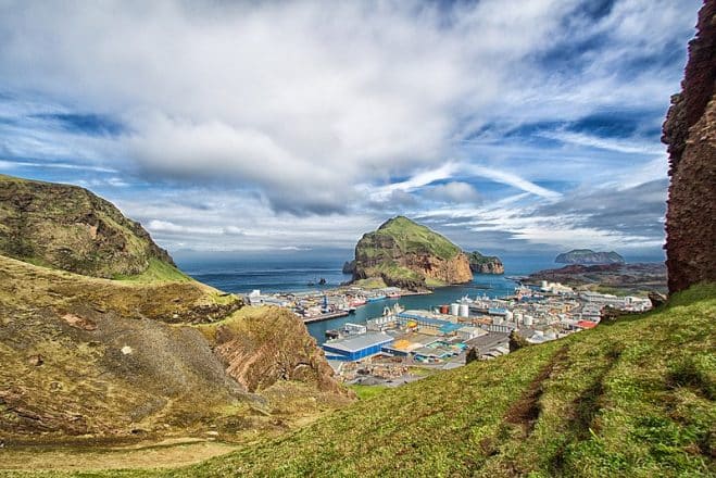
Heimaey is home to around 4500 people, a population widely outnumbered by the migrating Atlantic Puffins who arrive there to nest each summer. Numbering over 5-million, the world’s largest puffin colony can be found in Westman Islands
Heimaey boasts a fascinating history. In 1627, the island’s residents were kidnapped by roaming Ottoman raiders in an event later coined The Algerian Pirate Raid.
The story has become one of legend in Iceland, with many tales of heroism and vengeance having been spun from it in the years since.
In more recent times, Heimaey has felt the weight of Iceland’s elemental forces, having suffered a powerful eruption in January 1973. To the astonishment of residents, earthquakes and ground fissures began to form around the town’s landmark mountain, Eldfell.
At first, this didn’t seem to be much of a problem. The volcanic ash was blowing out to sea, and the fissures appeared to be closing. When the winds changed direction, however, the situation at once became more dramatic.
The subsequent lava flow threatened to overrun the town’s harbour and main source of livelihood, meaning an evacuation had to be quickly implemented.
This was largely achieved with the help of fishing boats and private owners from the mainland who made the crossing at their own peril.
Thanks to the bravery of those who stayed behind to combat the oncoming lava, the flow was diverted safely and the town’s harbour was saved.
There was only one death reported from the incident—one that could have been far worse under different circumstances.
Another of Vestmannaeyjar’s most famous islands is Surtsey, named after the Norse God of Fire, Surtur.
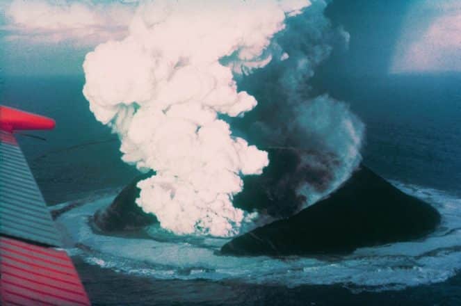
Before 1963, Surtsey didn’t exist. In November that year, a volcanic eruption began 130 metres (430 feet) underwater. On the 14th, the inferno-like tephra broke the surface and began building an island by way of mass and momentum.
This continued until 1967 when the island reached its maximum size of 2.7 km2 (1.0 sq mi). The island has since to diminished in size due to constant water eruption, and in 2012, its surface area was around 1.3 km2 (0.50 sq mi).
In the years since, the island has been monitored by an exclusive group of botanists and volcanologists, particularly in regards to how flora grows on a recently composed island.
- Learn more about Iceland with our selection of informative Articles and Blogs
Final Thoughts on South Iceland
In summary, South Iceland is a region rich with vibrant local culture and a fascinating history. More than that, it is a place defined by its eclectic and awe-inspiring environment.
The deserts, beaches and mountains. The meadows, glaciers and bubbling hot springs.
Sculpted by the fire and ice that has lent Iceland it’s nickname, South Iceland’s landscapes are like nowhere else on earth; raw, breathtaking, ever-changing—Mother’s Nature canvas, still left unfinished.
Whichever attractions and activities you choose to experience in the South Iceland region are sure to provide you with a lifetime of happy memories.
Be sure to browse our range of tours and excursions for your dream holiday in Iceland’s south.